en
wishlist
login
mail

contact us

Cartography

Hiking maps, maps and atlases, cartography around the world. Maps of the trails, cartography for cyclotourism and mountain biking

Mountain

Alpine guides, hiking guides, technical manuals for summer and winter mountaineering. Mountain literature and filmography

Sea

Nautical manuals, nautical cartography, books and literature for sailboat and motor

Travels

Travel guides and travel literature for Italy, Europe and the rest of the world

Military

Collection of the best publications (books and DVDs) on the mountain war on the Alps and the rest of Italy and Europe
back
La Porta del Cel
Editorial Alpina | Spagna | 2021 | 11,5 x 21 | 1:25.000

La Porta del Cel

Mapa oficial

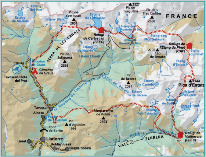
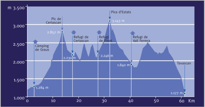
La Porta del Cel es un circuito de alta montaña del Pallars Sobirà, que enlaza cuatro refugios: el de Certascan, el de Pinet, el de Vallferrera y el del Camping de Graus, además de pasar por el pueblo de Tavascan y hacer un recorrido tanto por el Parque Natural del Alt Pirineu como por el  de Ariège.
El desnivel acumulado (ascenso y descenso) es superior a los 11.000 m y la distancia oscila los 65 km, por lo que tenemos que cargar en la mochila el mínimo imprescindible para un recorrido en la alta montaña. Los caminos poco trazados, la ascensión diaria de alguna cima, entre los que figura la Pica d’Estats, y el paso por heleros de nieve hasta bien entrado el verano, hacen de esta travesía algo especial.

Idioma: catalán y castellano

add to wish list
€ 15.00
quantity
- 1 +
ship to :: Italia
Corriere espresso € 6.00
availability
usually shipped within 15/30 days
add to cart