en
wishlist
login
mail

contact us

Cartography

Hiking maps, maps and atlases, cartography around the world. Maps of the trails, cartography for cyclotourism and mountain biking

Mountain

Alpine guides, hiking guides, technical manuals for summer and winter mountaineering. Mountain literature and filmography

Sea

Nautical manuals, nautical cartography, books and literature for sailboat and motor

Travels

Travel guides and travel literature for Italy, Europe and the rest of the world

Military

Collection of the best publications (books and DVDs) on the mountain war on the Alps and the rest of Italy and Europe
advanced search ricerca avanzata
back
-5%
Tour del Monte Rosa - Lungo gli antichi sentieri Walser stato
Geo4Map libreria geografica | Carte escursionistiche | Novara | impermeabile, antistrappo | 11 x 24

Tour del Monte Rosa - Lungo gli antichi sentieri Walser

Macugnaga - Zermatt - Valtounenche - Alagna Valsesia

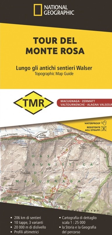
206 chilometri di sentiero, 10 tappe, 3 varianti, un itinerario alpino che si snoda attorno al massiccio del Monte Rosa attraversando le valli comprese tra Piemonte, Svizzera e Valle d’Aosta, lungo gli antichi sentieri Walser. È uno degli itinerari più panoramici e suggestivi dell’arco alpino dove la sfilata di imponenti Quattromila domina l’orizzonte e riempie lo sguardo. Questo stupefacente giro ad anello, che stringe in un abbraccio il maestoso massiccio, consente agli escursionisti più attenti e interessati di conoscere e apprezzare le genti e i paesaggi del gigante Rosa.


add to wish list
€ 14.16
instead of € 14.90
quantity
- 1 +
ship to :: Italia
Corriere espresso € 5.50
availability
out of stock