


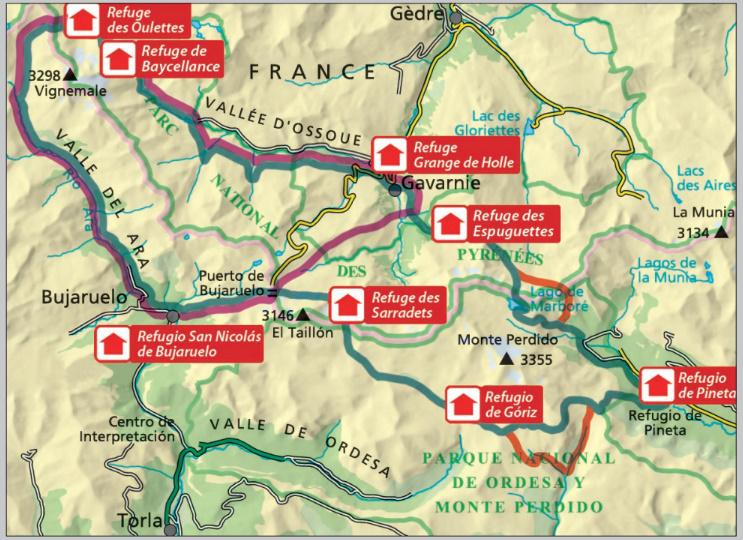
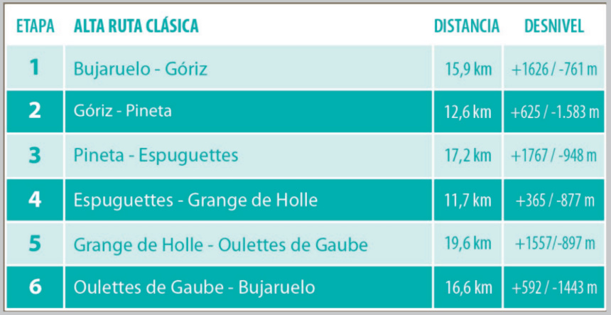
The Alta Ruta de los Perdidos (The High Route of the Lost) is a circular trek between mountain huts, completed in stages ranging from three to seven days, depending on the chosen mode. The route circles the massifs of Monte Perdido and Vignemale, allowing hikers to discover these two giants of the Pyrenees and their impressive north faces, still living glaciers, and majestic Pyrenean character, all surrounded by spectacular valleys such as Ordesa, Pineta, Añisclo, Bujaruelo, and Ossoue.
La Alta Ruta de los Perdidos (La Haute Route des Perduts) est un circuit en boucle entre refuges, réalisé en étapes de trois à sept jours, selon la formule choisie. L’itinéraire fait le tour des massifs du Mont Perdu et du Vignemale, permettant de découvrir ces deux géants des Pyrénées et leurs impressionnantes faces nord, leurs glaciers encore vivants et leur grandeur pyrénéenne, entourés de vallées spectaculaires comme Ordesa, Pineta, Añisclo, Bujaruelo et Ossoue.
L'Alta Ruta de los Perdidos (L'Alta Via dei Perduti) è un trekking circolare tra rifugi alpini, che si completa in tappe che vanno dai tre ai sette giorni, a seconda della modalità scelta. Il percorso circonda i massicci del Monte Perdido e del Vignemale, permettendo agli escursionisti di scoprire questi due giganti dei Pirenei e le loro imponenti pareti nord, i ghiacciai ancora attivi e il maestoso carattere pirenaico, il tutto circondato da valli spettacolari come Ordesa, Pineta, Añisclo, Bujaruelo e Ossoue.
Idioma del libro: Español
•Mapa y guía de senderismo
•Escala 1:30.000
•Curvas de equidistancia: 10 m
•Curvas maestras: a 50 m
•Relieve sombreado
•Compatible con GPS
•Rutas señalizadas
•Uso del suelo representado en tres niveles