


contact us
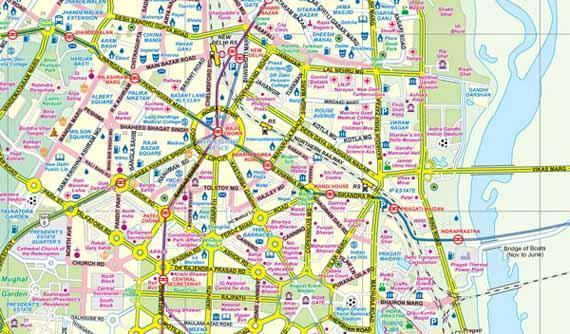
Northwestern India at 1:1,900,000 on an indexed map from ITMB, with the reverse side showing a street plan of Delhi with its outer suburbs, plus an enlargement of the Connaught Place central area and diagrams of the metro and rail networks.
On one side is an indexed road map of north-western India centred on Delhi and extending north to the Line of Control dividing Jammu and Kashmir. Coverage east along the Ganges extends beyond Varanasi; west to Jodhour, the outskirts of Ahmadabad and to Vadodara (Baroda); and south to Nagpur, the geographical centre of India. The map has altitude colouring (in feet) and shows the country’s road and rail networks and local airports. Symbols highlight various places of interest including historic or scenic sites, hill stations, temples and other religious buildings, castles and forts, national parks and wildlife reserves, etc. Latitude and longitude lines are drawn at intervals of 2°.
The reverse side is covered by a street plan of Delhi with its outer suburbs including Ghaziabad. Main traffic arteries are highlighted and many smaller streets are named. Where appropriate, sector or block numbers are provided. Metro stations are clearly marked. Symbols mark various places of interest including selected hotels, main sights, locations of petrol stations and overhead tanks, etc. The plan is indexed and includes an enlargement for the central Connaught Place area indicating main public buildings, accommodation and restaurants, banks, etc. Also provided are diagrams of the metro and railway networks.