


L'indispensable carte de randonnée IGN 2943ET. D'une très grande précision elle contient tous les détails existants sur le terrain : voies de communication jusqu'au moindre sentier, constructions jusqu'au hangar, bois, arbre isolé, rivière, source... Sans oublier la représentation du relief par des courbes de niveau. Les sentiers balisés et les informations touristiques sont également représentées.
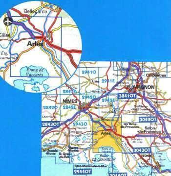
Communes couvertes : Arles, Bellegarde, Fourques, Saint-Gilles, Fontvieille
Lieux à découvrir : Massif des Alpilles, Parc naturel régional de Camargue, Marais de Meyranne, Étang de Vaccarès, Marais de la Grand Mar, Tête de la Camargue, Costières, Tour d'Amphoux, Ste-Croix, Château de l'Armellière, Cirque, St-Pierre de Montmajour, Mas de Méjanes, Écluse de St-Gilles, Château de la Jansonne, Réserve naturelle de Camargue, Musée de la Camargue, Abbatiale St-Gilles