en
wishlist
login
mail

contact us

Cartography

Hiking maps, maps and atlases, cartography around the world. Maps of the trails, cartography for cyclotourism and mountain biking

Mountain

Alpine guides, hiking guides, technical manuals for summer and winter mountaineering. Mountain literature and filmography

Sea

Nautical manuals, nautical cartography, books and literature for sailboat and motor

Travels

Travel guides and travel literature for Italy, Europe and the rest of the world

Military

Collection of the best publications (books and DVDs) on the mountain war on the Alps and the rest of Italy and Europe
back
D7 - TOTIUS ITALIAE TABULA PER NICOLAUM VISSCHER
IGMI Istituto Geografico Militare Italiano | Stampe antiche Carte Generali Italia | Firenze | 1664 (circa) | 37 x 28 | 1:2.850.000 circa

D7 - TOTIUS ITALIAE TABULA PER NICOLAUM VISSCHER

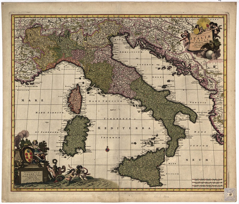
La carta è dedicata al "Serenissimo Principi Cosmo III Magno Etruriae Duci". E' a colori, adorna di bellissimi fregi artistici. Orientamento normale, proiezione conica, meridiano centrale 33°; le longitudini provengono dall'isola del Ferro. Orografia a volo d'uccello; ben curata l'idrografia; manca la viabilità. Il disegno comprende la penisola con tutte le tre grandi isole e, all'ovest Grenoble, al nord Friburgo, all'est il corso della Sava e l'isola di Corfù. In basso, a destra, triplice scala in miglia germaniche, francesi e italiane. Una particolarità di questa carta: immediatamente sopra il promontorio che si protende nel mare fra Cattolica e Pesaro, vi è la scritta "Conca città profondata".

add to wish list
€ 18.30
quantity
- 1 +
ship to :: Italia
Corriere espresso € 6.00
availability
usually shipped within 3/7 days
add to cart