en
wishlist
login
mail

contact us

Cartography

Hiking maps, maps and atlases, cartography around the world. Maps of the trails, cartography for cyclotourism and mountain biking

Mountain

Alpine guides, hiking guides, technical manuals for summer and winter mountaineering. Mountain literature and filmography

Sea

Nautical manuals, nautical cartography, books and literature for sailboat and motor

Travels

Travel guides and travel literature for Italy, Europe and the rest of the world

Military

Collection of the best publications (books and DVDs) on the mountain war on the Alps and the rest of Italy and Europe
back
E2 - ITALIAE GALLICA SIVE GALLIA CISALPINA, EX CONATIBUS GEOGRAPHICIS ABRAH. ORTELIJ
IGMI Istituto Geografico Militare Italiano | Stampe antiche Tavole di atlanti | Firenze | 1590-01-01 | 45 x 43 | 1:1.370.000 circa

E2 - ITALIAE GALLICA SIVE GALLIA CISALPINA, EX CONATIBUS GEOGRAPHICIS ABRAH. ORTELIJ

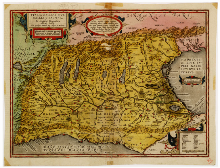
Tav.I-3 - Confini: nord, la catena delle Alpi; sud, Mar Ligure fino alla foce dell'Arno; est, le Caravanche ed il "Frigidus"; ovest, la displuviale alpina. Orografia a volo d'uccello. Carta acquerellata ed artisticamente pregevole. Il Documento contiene 7 tavole dell'Atlante pubblicato nel 1570 da Abramo Ortelio, dotto geografo e sommo cartografo, detto il Tolomeo del suo secolo, amico di Gerardo Mercatore, nato ad Anversa nel 1527, morto nel 1598. Altre edizioni di questo Atlante si ebbero nel 1571, nel 1573, nel 1592 e nel 1595; in queste il numero delle tavole andò via via aumentando da 53 della edizione primitiva, a 115 in quella del 1595. Nel 1608 Filippo Pigafetta pubblicò ad Anversa una edizione italiana di 127 tavole. Le tavole della prima edizione sono state incise da Francesco Hogenberg.

Regioni: Emilia-Romagna,Friuli-Venezia Giulia,Liguria,Lombardia,Piemonte,Toscana,Trentino-Alto Adige / Sudtirol,Valle D'Aosta / Vallee D'Aoste,Veneto

add to wish list
€ 18.30
quantity
- 1 +
ship to :: Italia
Corriere espresso € 6.00
availability
usually shipped within 3/7 days
add to cart