en
wishlist
login
mail

contact us

Cartography

Hiking maps, maps and atlases, cartography around the world. Maps of the trails, cartography for cyclotourism and mountain biking

Mountain

Alpine guides, hiking guides, technical manuals for summer and winter mountaineering. Mountain literature and filmography

Sea

Nautical manuals, nautical cartography, books and literature for sailboat and motor

Travels

Travel guides and travel literature for Italy, Europe and the rest of the world

Military

Collection of the best publications (books and DVDs) on the mountain war on the Alps and the rest of Italy and Europe
back
E8 - TABULA ITALIAE, CORSICAE, SARDINIAE ET ADIACENTIUM REGNORUM AMSTELREDAMI, APUD FREDERICUM DE WIT

E8 - TABULA ITALIAE, CORSICAE, SARDINIAE ET ADIACENTIUM REGNORUM AMSTELREDAMI, APUD FREDERICUM DE WIT

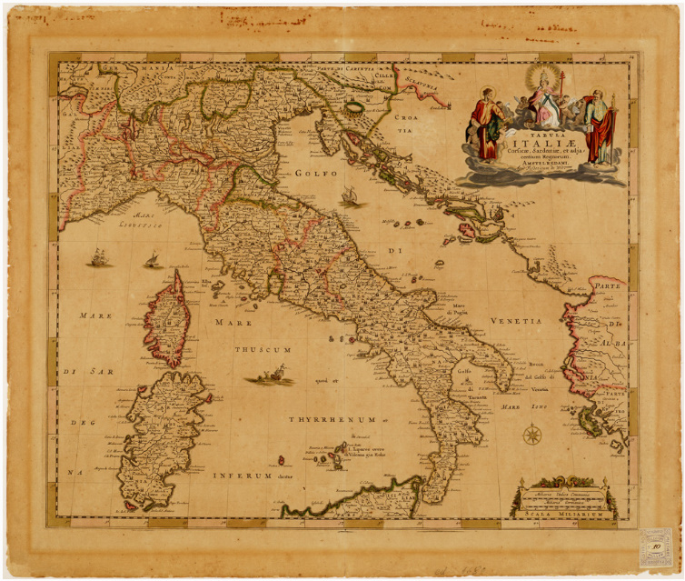
Incisione su rame in foglio unico. Limiti del campo disegnato: nord, Landeck; sud, Monte Etna; est, parte orientale dell'Albania e dell'Epiro; ovest, San Giovanni di Moriana. Proiezione conica, meridiano centrale 36°, orografia a volo d'uccello. Questa carta spicca per la relativa esattezza dell'articolazione delle coste. Il titolo è contenuto in artistico fregio con figure colorate all'acquerello e in oro. In basso a destra, doppia scala: in miglia italiane e in miglia germaniche comuni. Da questa carta deriva il documento Coll. Muller n. 9 - NOVISSIMA ET ACCURATISSIMA TOTIUS ITALIAE... Il de Wit con gli Hondius, i Blaew, i Jannson, i Fischer, largamente giovandosi dell'Atlante di Giovanni Antonio Magini (1620), fece rifulgere la cartografia olandese del secolo XVII.


add to wish list
€ 15.00
quantity
- 1 +
ship to :: Italia
Corriere espresso € 6.00
availability
usually shipped within 3/7 days
add to cart