en
wishlist
login
mail

contact us

Cartography

Hiking maps, maps and atlases, cartography around the world. Maps of the trails, cartography for cyclotourism and mountain biking

Mountain

Alpine guides, hiking guides, technical manuals for summer and winter mountaineering. Mountain literature and filmography

Sea

Nautical manuals, nautical cartography, books and literature for sailboat and motor

Travels

Travel guides and travel literature for Italy, Europe and the rest of the world

Military

Collection of the best publications (books and DVDs) on the mountain war on the Alps and the rest of Italy and Europe
back
B1 CARTA DEGLI STATI DI S. R. M. IL RE DI SARDEGNA TORINO, 1792. PRESSO I LIBRAI ORGEAS E FIGLI FERRERO E POMBA, BELTRAMO ANTONIO RE

B1 CARTA DEGLI STATI DI S. R. M. IL RE DI SARDEGNA TORINO, 1792. PRESSO I LIBRAI ORGEAS E FIGLI FERRERO E POMBA, BELTRAMO ANTONIO RE

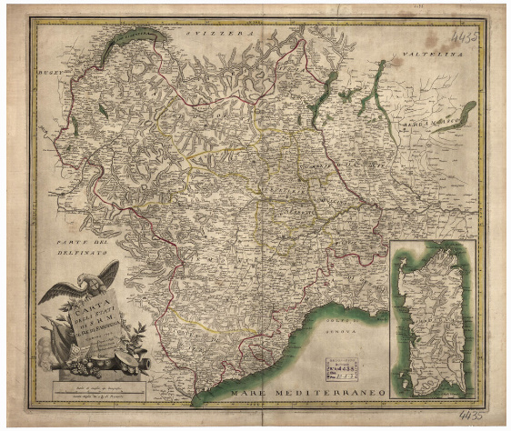
Sotto il titolo le scale grafiche, nella parte destra in basso un riquadro raffigurante l'Isola della Sardegna. Un foglio tratto da incisione su rame stampato in nero con confini a colori e acque costiere e dei laghi in azzurro. L'orografia è dimostrata schematicamente col tratteggio. Non è tracciata la rete stradale. In basso a destra una cartina supplementare dell'isola di Sardegna. La carta si estende dal lago di Ginevra (nord) al Golfo di Genova (Antibo-Rapallo) (sud) e da Grenoble (ovest) al Lago d'Iseo (est). .

add to wish list
€ 18.30
quantity
- 1 +
ship to :: Italia
Corriere espresso € 6.00
availability
usually shipped within 3/7 days
add to cart