


Hiking map Soca Valley, Isonzo, Alpi Giulie / Julian Alps, Triglav, Nova Gorica: The map for hiking, cycling and many other activities in nature. Compass hiking maps are easy to read and still contain all the information you need for a perfect hiking tour, a bike ride or an excursion. They depict nature at the right scale. Countless additional information is continually checked and expanded by the cartography team. The precise cartography includes all official hiking trails with names and trail numbers (such as long-distance trails), cycle paths (with trails), via ferratas, inns and huts, parking lots, buses and trains, ski tours and cross-country ski trails, springs, swimming areas and much more. This makes the map ideal for discovering new destinations, planning tours and finding your way around on the go. An intuitive map image of the landscape is created by the depicted vegetation, contour lines, rock drawings and the shading (shadows) of the mountains. Features of the hiking map Soca Valley, Isonzo, Alpi Giulie / Julian Alps, Triglav, Nova Gorica: - Scale 1:50,000: 1cm on the main map corresponds to 500m in nature.
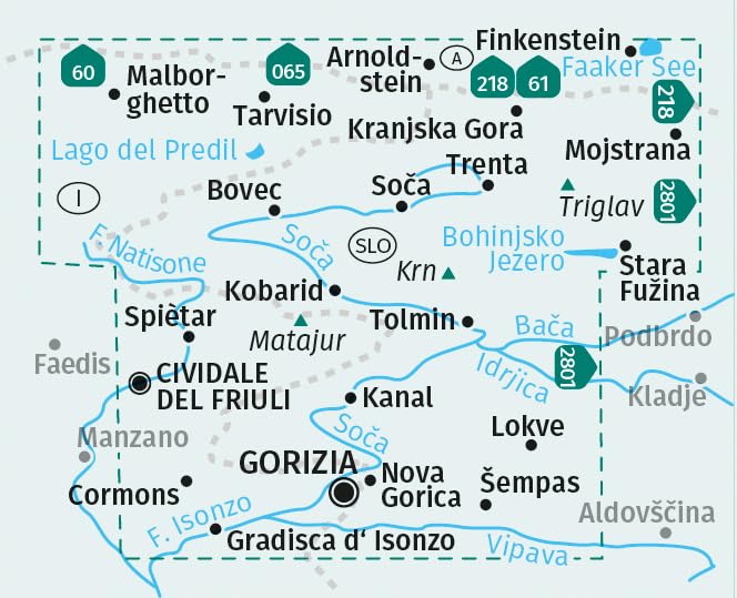
About the region: About the regionSoca Valley: The Soca Valley, also known as the Isonzo Valley, is a breathtaking hiking region in the Julian Alps. The emerald-green Soca, one of the most beautiful rivers in Europe, meanders through a spectacular landscape of deep gorges and rugged mountain peaks. The city of Nova Gorica is an ideal starting point for exploring this fascinating region. Alpi Giulie: The Alpi Giulie, or Julian Alps, are a paradise for mountain hikers. Here rises the majestic Triglav, Slovenia's highest peak at 2,864 meters. The region is characterized by a diverse landscape, from steep rock faces to green alpine meadows. The towns of Kranjska Gora and Bovec are popular destinations for outdoor enthusiasts.
Primary language: German
Double face