


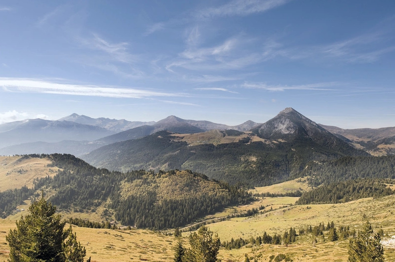
Begin an unforgettable journey along the Peaks of the Balkans trail, one of Europe’s most spectacular long-distance hiking trails. This remote and rewarding circular trek spans approximately 192 km (119 miles) through the rugged mountain regions of Albania, Kosovo, and Montenegro, offering a rare opportunity to experience some of the continent’s last truly unspoiled wilderness. The route takes you across high alpine passes, deep valleys, and traditional villages, immersing you in the timeless culture of the Balkans.
Usually completed in 9-10 days, the trail suits fit experienced hikers but requires no technical skills. The Peaks of the Balkans trail is known for dramatic scenery, local hospitality, and the rare experience of crossing borders on foot. Written by award-winning travel writer Rudolf Abraham, this comprehensive Cicerone guidebook is the essential resource for planning your trek.
Stage-by-stage route descriptions guide you through the Peaks of the Balkans in a circular loop, with 1:50,000-scale maps to help you navigate the dramatic landscapes of Albania, Kosovo, and Montenegro with confidence.
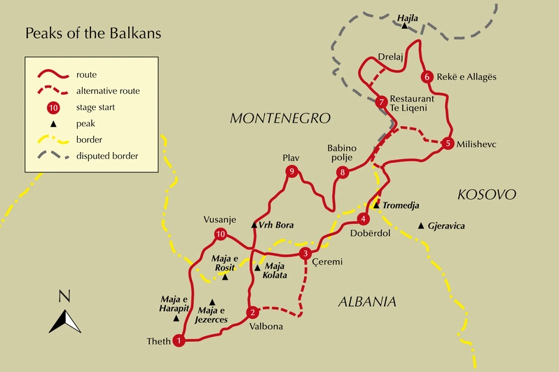
The trail is divided into 10 stages, with advice on completing the route in 8 days for faster trekkers. Each stage connects mountain villages such as Valbona, Theth, Dobërdol, Plav, and Vusanje, giving you the flexibility to plan your journey around these key points.
Optional detours and side trips are included, such as visiting the Grbaja Valley from Plav, climbing Gjeravica or Hajla, or exploring classic highlights like Valbona Valley and Theth National Parks, so you can customise your adventure and discover more of the region’s standout locations.
Each stage details start and finish points, daily distances, elevation profiles, and accommodation options—such as guesthouses and mountain huts—in villages like Valbona, Theth, Plav, and Dobërdol, to help you shape your journey.
Downloadable GPX files provide digital navigation, allowing you to confidently follow the Peaks of the Balkans route on your smartphone or GPS device through some of the Balkans’ most spectacular mountain scenery.
Practical advice covers border crossings between Albania, Kosovo, and Montenegro, permits, transport to trailheads like Plav or Valbona, and local customs, ensuring a seamless experience along the international route.
The guide recommends hiking from June to September, when snow has cleared mountain passes such as Qafa e Pejës and guesthouses along the route, including in Theth, Valbona, and Dobërdol, are open to welcome travellers.
Plan your Peaks of the Balkans adventure with confidence and enjoy one of Europe’s most iconic multi-country hikes with this definitive guidebook.
The Peaks of the Balkans Trail - Quick Facts
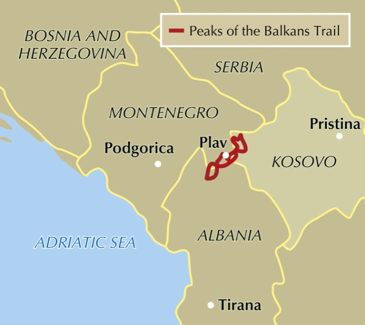
Location: Montenegro, Albania & Kosovo (cross‑border circuit)
Distance: ~192 km / ~119 miles
Typical duration: ~9–10 days (can be extended over ~2 weeks)
Start & end: Circular route (commonly begun at Theth, Albania)
Route format: Circular long‑distance alpine trek across remote borderlands
Stages: 10 stages with detailed daily descriptions
Difficulty: Moderate – rugged mountain passes and varied terrain; fit walkers recommended
Best season: June–September (snow‑free high passes and open guesthouses)
Contents
Map key
Overview maps
Route summary table
Introduction
Geography and geology
Historical summary
National parks and nature reserves
Environmental issues
Wildlife and plants
Climate
When to hike
Getting there and around
Accommodation and food
Public holidays
Language
Money
Phones, internet and electricity
Cross-border permits
Local tour operators
Where to start/finish
Variations, transfers and highlights
Trail markings
Maps
Equipment
Water
Safety in the mountains and what to do in an emergency
Using this guide
The Peaks of the Balkans Trail
Stage 1 Theth (Albania) – Valbona (Albania)
Stage 2 Valbona (Albania) – Çeremi (Albania) via the Prosllopit Pass
Stage 3 Çeremi (Albania) – Dobërdol (Albania)
Stage 4 Dobërdol (Albania) – Milishevc (Kosovo)
Stage 5 Milishevc (Kosovo) – Rekë e Allagës (Kosovo)
Stage 6 Rekë e Allagës (Kosovo) – Drelaj or Restaurant Te Liqeni (Kosovo)
Stage 7 Restaurant Te Liqeni (Kosovo) – Babino polje (Montenegro)
Stage 8 Babino polje (Montenegro) – Plav (Montenegro)
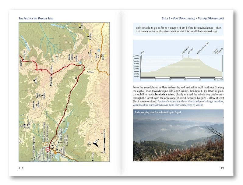
Stage 9 Plav (Montenegro) – Vusanje (Montenegro)
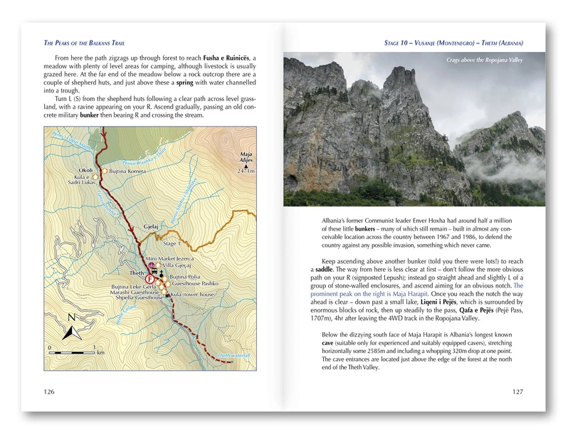
Stage 10 Vusanje (Montenegro) – Theth (Albania)
Appendix A Useful contacts
Appendix B Accommodation
Appendix C Further reading
Appendix D Language and glossary
Appendix E History timeline