it
wishlist
login
mail

contattaci

Cartografia

Carte escursionistiche, carte stradali e atlanti, cartografia d'Italia e di tutto il mondo. Carte dei sentieri, cartografia per il cicloturismo e mountain bike

Montagna

Guide alpinistiche, guide escursionistiche, manuali tecnici per l'alpinismo estivo ed invernale. Letteratura e filmografia di montagna

Mare

Manuali nautici, cartografia nautica, libri e letteratura per la barca a vela e motore

Viaggi

Guide turistiche per viaggi e letteratura di viaggio per l'Italia, l'Europa e tutto il Mondo

Militaria

Raccolta delle migliori pubblicazioni (libri e dvd) sulla guerra in montagna sulle Alpi e sul resto d'Italia e d'Europa
ricerca avanzata ricerca avanzata
indietro
Tahiti
ITMB | Carte stradali | Vancouver | 2011 | 10 x 25 | 1:100.000

Tahiti

1:100.000

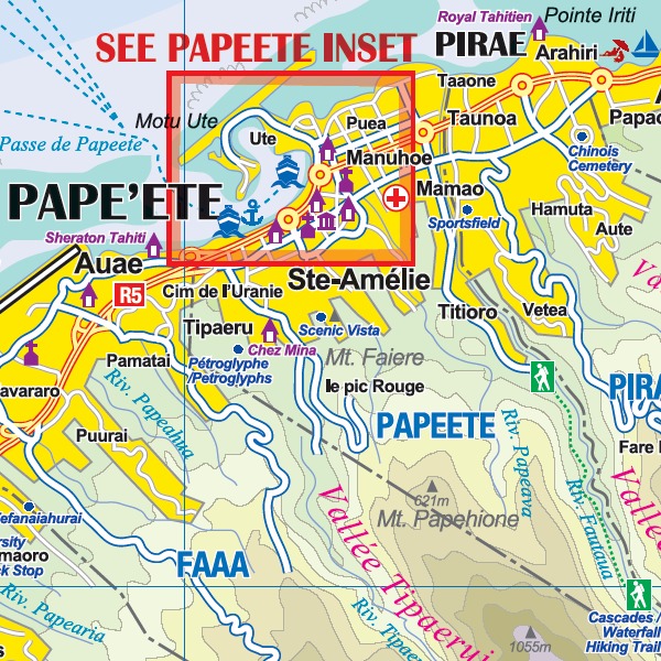
ITMB is pleased to add to our extensive range of South Pacific maps with the release of Tahiti and the nearby Society islands of Bora Bora, Moorea, Tahaa, and Raiatea. To expand the land information, we have prepared each island as an inset, with a separate inset showing the islands in relation to each other. A detailed inset of Papeete, the capital, is also included. Tahiti forms part of the French overseas possessions and, as such, is part of the European Community. The island of Tahiti Nui is the most developed of the islands, and the map shows numerous dive sites and beaches. Most of the resorts are located close to Papeete and the airport, but eacho] of the islands has resort accommodation shown. Bora Bora seems to be well-endowed with resorts. Again, this map is considerably less expensive than the ‘other’ map on the market, and is much more oriented to the needs of travellers.
 

aggiungi alla lista dei desideri
€ 11.00
quantità
- 1 +
spedizione :: Italia
Corriere espresso € 5.50
disponibilità
immediata - spedito entro 24/48 ore
Aggiungi al carrello