it
wishlist
login
mail

contattaci

Cartografia

Carte escursionistiche, carte stradali e atlanti, cartografia d'Italia e di tutto il mondo. Carte dei sentieri, cartografia per il cicloturismo e mountain bike

Montagna

Guide alpinistiche, guide escursionistiche, manuali tecnici per l'alpinismo estivo ed invernale. Letteratura e filmografia di montagna

Mare

Manuali nautici, cartografia nautica, libri e letteratura per la barca a vela e motore

Viaggi

Guide turistiche per viaggi e letteratura di viaggio per l'Italia, l'Europa e tutto il Mondo

Militaria

Raccolta delle migliori pubblicazioni (libri e dvd) sulla guerra in montagna sulle Alpi e sul resto d'Italia e d'Europa
indietro
Congo Repubblica Democratica e Repubblica Centrafricana
ITMB | Carte stradali | Vancouver | 02/2012 | 10 x 25 | 1:2.000.000

Congo Repubblica Democratica e Repubblica Centrafricana

1:2.000.000

Congo (Congo-Brazzaville and the Democratic Republic of Congo) plus the Central African Republic on an indexed, double-sided map with a very large number of place names of small towns and villages.

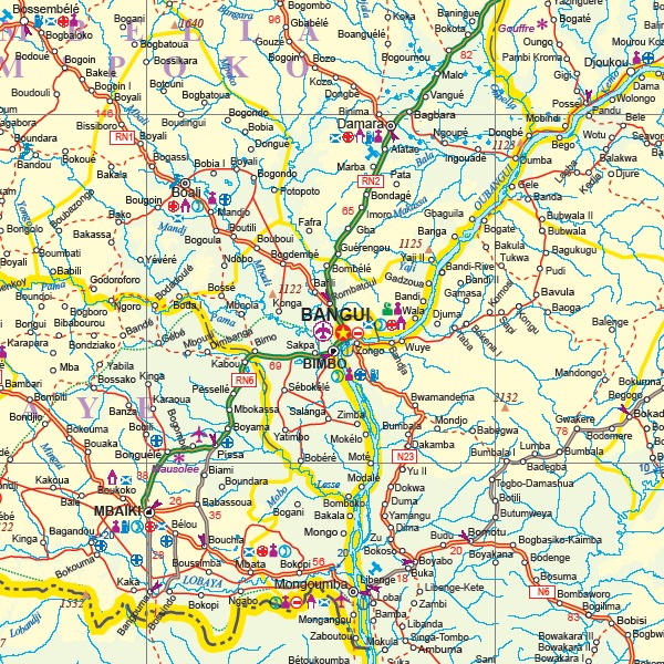
The map covers all of the Democratic Republic of Congo (the former Congo-Kinshasa, or Zaire), all of the People’s Republic of the Congo (known as Congo-Brazzaville or French Congo), and the Central African Republic to the north. This is in reality a map of the vast rain forest known as the Congo River Basin. A word of warning: the road network in the Congo is primitive – that means largely non-existent or in such poor condition as to wreck army trucks. We show the roads, and tried to classify them by quality, but this is a ‘work in progress’ and I hope that this map will create sufficient feedback to improve this aspect of the map. For this edition, we have laid the ground work for developing more detailed sectional maps as the need arises.

aggiungi alla lista dei desideri
€ 13.00
quantità
- 1 +
spedizione :: Italia
Corriere espresso € 5.50
disponibilità
immediata - spedito entro 24/48 ore
Aggiungi al carrello